")


Walking in Lanzarote
£13.00
68 long and short walks and 3 car tours
by Noel Rochford
25% off your next ebook when you sign up to our newsletter! Sign up here.
A guidebook to walking in Lanzarote in the Canary Islands, featuring 68 of the best long and short day walks. We cover the whole of Lanzarote and include a day-trip to explore northern Fuerteventura by car (including a 5-star walk on that island).
Trekking routes of varying difficulty are featured, all of which are mapped in detail, and many of the hikes are circular.
This guide also includes 3 car tours, touring maps of both Lanzarote and northern Fuerteventura, plans of Arrecife, Puerto del Carmen, Playa Blanca and Corralejo (Fuerteventura).
When to go: The best time for walking in Lanzarote is from October to June.
Print book: £15.99 / PDF book: £13.00
![]()
Buy as a PDF download today:

This new 7th edition of our guidebook to walking on Lanzarote has been completely redesigned in a wider format – with larger type and no mapping lost in the gutter. Free downloadable GPS tracks with waypoints are also available for all the hikes.
Colour coding on the contents page enables you to see at a glance the grading of various treks.
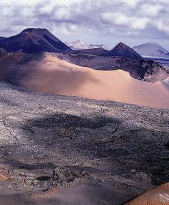
Fascinating Lanzarote is truly extraordinary. Its fate was decided some two and one-half centuries ago, when the largest volcanic eruption in recorded history took place, leaving a strange and alluring countryside in its wake — a landscape littered with volcanoes and dark streams of jagged lava. This is the backdrop to nearly every scene on the island, and intriguing sights abound – none more so than the ‘Fire Mountains’.
As for hiking in Lanzarote, there is no better place in the Canaries for just strolling, but trekkers will also be able to put part of the GR131 under their belts. Each of the walks in this book takes you to a different corner of the island and shows you a scenically different outlook.
But if walking is not your favourite pastime, then do explore Lanzarote by car.
What’s great about this book is that it gives loads of detailed and useful information [about] places off the beaten track that I’d never thought of visiting. (ML, Amazon)
I can’t imagine going to Lanzarote without this book. (NN, Amazon)
I thought I’d let you know just how valuable your book was on our recent trip to Lanzarote. Whilst other holidaymakers were going on the usual excursions, we went off the beaten track — following your picnic suggestions. I found your book very informative on all aspects and the maps were useful and accurate.(D&ET, West Hagley)
Walkers relying on public transport should stay in Arrecife (the capital), with buses to all areas. Otherwise, at least five walks will be accessibe from each of the four major resorts: Puerto del Carmen, Costa Teguise, Playa Blanca and Puerto Calero.
3 car tours, 68 long and short walks, 16 picnic suggestions
Includes a day trip to neighbouring Fuerteventura
168 pages + 2 touring maps (Lanzarote and northern Fuerteventura); plans of Arrecife, Puerto del Carmen, Playa Blanca and Corralejo (Fuerteventura); large-scale (1:50,000) topo maps
7th ed, March 2022; ISBN 978-1-85691-539-7; UK retail price £15.99 / USA retail price $21.00
Table of contents:
Preface 5
Acknowledgements 6
Useful books 6
Getting about 7
Plan of Puerto del Carmen 6-7
Plans of Arrecife, Playa Blanca 8-9
Picnicking 10
Picnic suggestions 11
Touring 16
Car tour 1: THE SIGHTS OF THE NORTH 21
Puerto del Carmen • Tahiche • Arrieta • Jameos del Água • Cueva de los Verdes • Órzola • Mirador del Río • Haría •
Teguise • La Caleta de Famara • Mozaga • Puerto del Carmen
Car tour 2: TIMANFAYA AND THE SOUTHERN BEACHES 30
Puerto del Carmen • San Bartolomé • Tinajo • La Santa • Montañas del Fuego • Yaiza • El Golfo • Playa Blanca •
Papagayo • Femés • La Geria Valley • San Bartolomé • Puerto del Carmen
Walking (see explanation of symbols on page 40) 40
Grading, waymarking, maps, GPS 40
Where to stay 41
What to take 42
Weather 42
Nuisances 43
Organisation of the walks 43
Spanish for walkers 44
A country code for walkers and motorists 46
THE WALKS
1 Around La Graciosa 47
2 Risco de Famara 51
3 Famara Circuit 55
4 From Máguez to Yé 57
5 Two approaches to Monte Corona 60
6 Helechos circuit from Máguez 62
7 Above the Guinate Valley 65
8 Around Haría 68
9 Mirador del Bosquecillo and the Valle de Malpaso 72
10 Haría • Restaurante Los Helechos • Ermita de las Nieves • Teguise 75
11 Mala • Ermita de las Nieves • Teguise 78
12 Circuit from Teguise via Los Valles 83
13 Circuit from Tabayesco and the adventurous PR LZ 01 86
14 Mancha Blanca • Playa de la Madera • Tinajo 90
15 Montaña del Cuervo 93
16 Caldera (or Montaña) Colorada 95
17 Caldera Blanca 98
18 Playa de la Madera to El Golfo — the Timanfaya coastal path 100
19 Circuit from El Golfo via Playa del Paso 103
20 Circuit from Uga via Montaña Tinasoria 105
21 Uga • Montaña de Guardilama • Puerto del Carmen 107
22 Uga • Montaña Tinasoria • Puerto Calero (or Puerto del Carmen) 110
23 Playa Quemada to Puerto del Carmen 112
24 Coastal promenade from Puerto del Carmen to Arrecife 114
25 Montaña Blanca 116
26 Atalaya de Femés from Yaiza 118
27 More walks to the Atalaya de Femés 122
28 Three barrancos circuit from Femés 124
29 Femés • Barranco de la Higuera • Playa Quemada • Puerto del Carmen 128
30 Playa de Papagayo 130
31 Los Ajaches — from Playa Blanca to Femés 132
32 Montaña Roja 136
33 Grand coastal tour from Playa Blanca to La Hoya, Part 1 138
34 Circuit from La Hoya via the Bufadero del Rincón del Palo 140
35 Montaña Corona (Costa Teguise) 145
36 Los Cocoteros to Costa Teguise 147
37 Timanfaya — the Tremesana route 150
CAR TOUR 3: A DAY OUT ON FUERTEVENTURA 156
Playa Blanca • Corralejo • Dunes Natural Park • (Puerto del Rosario) • Caleta de Fuste • Antigua • Tuineje • Pájara •
Puerto de la Peña • Betancuria • La Oliva • (El Cotillo) • Lajares • Corralejo • Playa Blanca
WALK
38 Five-star circuit from Ajuy 162
Bus and ferry timetables 165
Index 167
Fold-out maps (with plan of Corralejo) inside back cover
Ancones 148-9
Arrecife 114-5, 115; town plan 8-9
Arrieta 21, 22, 23, 64, 74, 80, 86, 88, 89
Atalaya de Femés 15, 38, 118, 119, 120, 121, 122, 123, 124, 126, 129
Barranco/Valle
de Chafariz 4, 15, 23, 86, 87, 88, 88, 89
de la Casita 125, 126
de la Higuera 124, 125, 126, 127, 128, 129
de los Castillejos 13, 68, 69, 70, 71
de los Dises 16, 126, 132-3, 135
de Malpaso 13, 69, 72, 73, 74
del Cuchillo 15, 68, 69, 87, 88, 88, 89
del Palomo 15, 78, 79, 80-1, 86, 87, 88, 89
del Quiquere 109, 110, 110, 112
del Rincón 68, 69, 71, 73
Parrado 132-3, 135
Bufadero del Rincón del Palo 138, 139, 140, 143, 144
Caldera
Blanca 41, 98, 99
Colorada 95, 96-7
Rajada 25, 154
Caleta del Congrio 16, 38, 132-3, 134
Castillo de Santa Bárbara 15, 21, 29, 80-1, 80-1, 82
Charco de los Clicos 10-1, 35, 36, 104
Costa Teguise 17, 19, 21, 22, 30, 41, 145, 146, 147, 148, 148-9, 154, 165, 166
Cueva de los Verdes 21, 24
Degollada del Portugués 16, 125, 126, 129, 132-3, 135
El Bosquecillo 10, 21, 28, 72-3, 73, 74
El Golfo 10-1, 16, 30, 35, 36, 100, 102-3, 104
El Rubicón (plain) 37, 38, 121, 125, 126, 132-3, 136, 139, 141
Ermita
de las Nieves 14, 68, 75, 76-7, 78, 80-1, 82, 83, 84, 85, 88, 89
de San José 15, 29, 82, 84
Famara
cliffs see Risco de Famara
La Caleta de Famara 21, 29, 53, 55, 56
Playa de Famara 56, 67, 72, 73, 74
urbanización 29, 53, 56
Femés 15, 16, 30, 38, 112, 118, 119, 120-1, 122, 123, 124, 125, 125, 126, 127, 128, 129, 129, 132-3, 135, 165
Fuerteventura 41, 155-164
Ajuy 155, 159, 162, 163
Antigua 155, 156, 157
Barranco de la Madre del Água 162-3, 163
Betancuria 155, 156, 158, 159, 160
Caleta de Fuste 155, 156, 157
Corralejo
town plan: touring map
Dunes Natural Park 155, 156, 157
El Cotillo 155, 156, 160, 161
Jandía Peninsula 156
Lajares 155, 156, 161
La Oliva 155, 156, 159, 160, 161
Llanos de la Concepción 160
Los Molinos 157
Montaña Tindaya 160
Pájara 155, 156, 158, 159, 161, 162
Presa de las Peñitas 159
Puerto de la Peña 162, 163, 164
Puerto del Rosario 157
Tefía 160
Tindaya 160, 166
Tiscamanita 157
Tuineje 155, 156, 157, 158
Valles de Ortega 157
Vega de Río Palmas 154, 159
Guatiza 17, 21, 22, 78, 148
Guinate 21, 27, 57, 59, 61, 62-3, 64, 65, 66, 67
Hacha Grande 16, 126, 132-3, 135
Haría 1, 13, 21, 27, 28, 45, 51, 52, 53, 64, 68, 69, 70, 71, 72, 73, 74, 75, 78, 81, 86, 87, 88
Islote de Hilario 34, 35
Jameos del Água 21, 22, 23, 24-5
Jardín de Cactus 22, 23
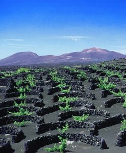
La Geria 15, 16, 17, 21, 30-1, 39, 93, 98, 105, 106, 107, 108, 110, 111, 112, 120
La Graciosa 11, 12, 13, 25, 26, 46-7, 48, 49, 52, 53, 54, 62, 63, 65, 67, 166
Caleta del Sebo 47, 48, 49, 50
Montaña Clara 26, 48, 49, 52
Pedro Barba 47, 48, 49, 50
Playa de las Conchas 46-7, 48, 49, 50
Playa de la Lambra 47, 48, 49
La Hoya 16, 36, 138, 139, 140, 143, 144
La Isleta 30, 31, 33
La Santa 30, 33, 71, 90, 98, 165, 166
Las Breñas 30, 36, 121, 132-3, 140, 141
Lobos 38, 106, 121, 134, 147, 154, 156, 166
Los Ajaches 36, 38, 106, 113, 124, 128, 131, 132-3, 135, 141
Los Cocoteros 17, 22, 147, 148, 149
Los Helechos 13, 28, 62-3, 64, 65, 66, 68, 70, 75, 77, 86, 87, 88
Los Hervideros 36, 37
Los Valles 29, 81, 83, 84, 85, 165
Los Volcanes Natural Park 93, 98
Máguez 12, 13, 14, 27, 28, 44, 51, 52, 54, 57, 59, 60, 61, 62, 63, 64,65, 66, 66, 70, 71, 81, 87, 145, 165
Mala 23, 64, 78, 79, 80-1, 86, 89
Mancha Blanca 30, 33, 34, 41, 90-1, 93, 95, 98, 99, 116
Masdache 31, 39
Mirador del Río 11, 12, 19, 25, 26, 49, 50, 51, 52, 59
Montaña see also Monte, Pico
Bermeja (near El Golfo) 33, 36, 37, 47, 49, 50
Blanca (near Montaña Blanca village) 116-7,117, 165
Caldereta 15, 41, 91, 98, 99
Corona (Costa Teguise) 145, 146, 146
de Guardilama 15, 93, 105, 106, 107, 108, 109
de Tenezar 31, 91, 92
del Cuervo 93, 94, 95, 97
Encantada 154
Ganada 70, 71, 72-3, 73, 74
Mina 22, 31
Negra 93, 95, 96, 104
Quemada 104
Roja 16, 125, 136-7, 137
Tinasoria 105, 106, 108, 111
Montañas del Fuego see Timanfaya
Monte Corona (Máguez) 13, 24, 25, 26, 27, 57, 58, 59, 60-1, 61, 62, 63, 64, 69, 70
Monumento al Campesino 29, 30, 32-3, 39
Mozaga 21, 29, 32, 33
Órzola 11, 19, 22, 23, 25, 26, 40, 45, 164, 166
Parque Eólico 28, 29
Peña de la Pequeña 15, 28, 87, 88, 89
Peñas del Chache 28, 68, 69, 73, 76-7, 81
Pico see also Montaña
de la Aceituna 124, 125, 126, 128
Redondo 125, 126, 135
Piedra Alta 101, 139, 142, 143
Playa
de Famara 27, 28, 54-5, 56, 81
de Janubio 139, 140, 141, 144
de Papagayo 14, 15, 16, 30, 31, 37, 38, 126, 130, 131, 132-3, 134, 135, 138, cover
del Paso 15, 36, 100-1, 102-3, 104
del Pozo 130, 131
del Risco 26, 48, 52, 53, 54
de la Cera 130, 131, cover
de la Madera 31, 36, 90, 92, 100-1, 150
Mujeres 130, 131, 132-3
Playa Blanca 16, 19, 21, 30, 36, 37, 38, 40, 41, 105, 107, 113, 118, 124, 125, 129, 130, 131, 132-3, 136, 137, 138,
139, 140, 155, 156, 165, 166
town plan 8-9
Playa Honda 114-5, 165
Playa Quemada 110, 112-3, 113, 126, 128, 129
Playa Teneza 31
Pozos de San Marcial 131, 132-3
Puerto Calero 41, 109, 111, 112-3, 126, 165, 166
Puerto del Carmen 19, 21, 22, 29, 30, 31, 38-9, 41, 107, 110, 111, 112-3, 114-5, 128, 134, 165, 166
town plan 6-7
Punta de Pechiguera 16, 125, 136, 137, 138, 139, 139
Risco de Famara 11, 28, 29, 48, 51, 52, 52, 53, 56, 71, 64, 65, 66, 69, 73, 74, 76-7, 81, 92, 107
Salinas de Janubio 36, 138, 143, 144, 153
Salinas del Río 51, 52, 52, 53, 54
San Bartolomé 22, 29, 30, 31, 39, 116, 117
Sóo 29, 71
Tabayesco 23, 86, 88, 88, 89
Tahiche 18, 21, 22, 32-3, 154
Tao 29, 32
Teguise 15, 17, 18, 19, 20, 21, 22, 28, 29, 30, 31, 41, 75, 76-7, 78, 80-1, 80-1, 82-3, 84, 85, 145, 146, 147, 149, 154,
165, 166
town plan 77
Tiagua 21, 29, 32
Tías 31, 134
Timanfaya National Park 2, 18-9, 21, 30-1, 39, 40, 90-1, 92, 96, 100, 101, 102-3, 104, 150-1, 152-3, 154
Tinajo 30, 31, 32, 33, 39, 90-1, 92, 98, 165
Uga 15, 39, 105, 106, 107, 108, 110, 111, 120
Valle see Barranco/Valle
Yaiza 30, 31, 34, 35, 118-9, 119, 120-1, 122, 123, 151, 154
Yé 26, 27, 57, 59, 60, 61
Lanzarote, 7th edition (2022); Updated 13/03/2024
Updates for walks and car tours (drives) on Lanzarote given below supplement those provided in the guidebook. It is vital that this Update is read in conjunction with the text of the book, but note that the Update applies only to the edition stated and not to any earlier editions. (If you have an older edition of this book you can “upgrade” to the latest edition at half price.)
Information has been forwarded to us by users of the book, and Sunflower Books offers the data in good faith but cannot be held responsible for any misleading or inaccurate content in the Update. Unless indicated otherwise, what appears here has not been verified by the author or publisher, so please allow due caution when new or amended routes are suggested. Each piece of information is dated; bear in mind that some of the older observations may have since been overtaken by events or further changes. If, during your holiday, you are using the current edition of the guide and are able to provide any additional updating to add to this page, we will be pleased to hear from you. Please send information, preferably by e-mail, to info@sunflowerbooks.co.uk.
BUSES: I’m just back from a week’s walking in Lanzorote. The guidebook was great and we did walks: 4, 5b, 9, 12, 22 and 36 from Arrecife using local buses. I agree with the update comments related to Walk 22; and we extended walk 36 by getting the bus to the Cactus Garden and walking to Charco Del Palo (before getting to Los Cocoteros). I thought you might be interested in our experiences of using the buses. We always set off from the main bus station (Estacion De Guaguas) where there are electronic displays both inside and by the individual bus stops (there’s also a manned desk during office open hours and on weekend mornings, however, they’re often very busy). In our experience, the displays rarely matched the reality! E.g, there’d be no mention of a bus, that would turn up within 10 minutes of checking; or when trying to return to the airport, the display said a bus was due in 7 minutes (didn’t appear) and then 32 minutes (another no show). We eventually spoke to the the office who said it would be 90 minutes before the next bus would appear! Ironically we found the return buses in the small towns, where there was just a printed timetable, to be much more reliable. Our advice would be, have alternative walks planned, so if there are problems getting the bus to your first choice, you can change your plans according to bus availability. I should also add we had the Moovit and local bus service apps loaded on our phones, neither of which helped to overcome the above problems. Having said all of that, we had a fantastic time and I would recommend Lanzarote(and your guide) as a walking destination. (User, 3/24)
Fold-out map: The ‘Walk 25’ in a circle near Orzola is a hangover from a previous edition. This short walk is on page 25 in the current edition, near the text for Orzola in the car tour. There is also an extraneous “31” in the area between Sóo and La Caleta, which has no explanation! (Sunflower)
Walk 7: This walk works well. (User, 11/22)
Walk 20: l was unable to locate the trig point on the top of Montana Tinasoria despite it being a gin clear day. There was, however, a large cairn near the top, so we used that as a reference point instead, and the route beyond that to the ‘line of larger rocks’ was clear enough. (User, 01/24) • We have just completed this walk today. There is a locked metal gate at the pass at Monte Tinasoria, but the walk continues past on the left of the gate. With very strong NE winds today we did find the ascent from the pass very challenging, and dared not try to find the stone seat mentioned as it was too difficult just to remain standing. The descent looked formidably steep, with the wind behind, but in fact it was ok. The pictures in the book look lovely, but sadly all we saw was arid brown earth as far as you could see. (User, 2/24) [Sunflower: The photos in the book were probably taken in spring…]
Walk 22: See the entry for Walk 20. This route is probably okay. (Sunflower)
Walk 25: This route – going for the summit right away and not circling the whole mountain before rising works well! (User, 11/22)
Walk 30: A new development is growing just next to Papagayo Arena (the easternmost hotel). Walkers have trodden a new path bypassing the new development (seems like an apartment complex) that rises right from the outset to drop down and cross a gully. I guess it’s still straight forward even for first comers, but be aware of this. (User, 11/22)
Walk 32: How to get there by car is incorrect and should read: “… Pass the Elba Lanzarote on the left in under 1km, go straight over the next roundabout and, at the next roundabout turn right (sign: Jardines del Sol). Pass the Jardines del Sol on the left, and when you are level with the Hotel Paradise Island on the right, turn left (Calle Noruga, signed to Montaña Baja, Los Claveles, among others). Keep ahead uphill for about 0.5km, then park in one of the streets below the easily-seen path up to a mobile phone mast and the crater (28° 52.179N, 13° 50.905 W).
GPS files for use with Lanzarote:
Download GPS files for Lanzarote
iPhone users need a free or paid app to open the zip file and see the files stored inside it. There are a variety of apps that can open zip files on the iPhone, but Zip Viewer is one of the easiest to use – and it is free.
You may also like…