


")


Walking in Eastern Provence – Côte d’Azur to the Alps
£14.00
70 long and short walks and 10 car tours
by John & Pat Underwood
25% off your next ebook when you sign up to our newsletter! Sign up here.
A guidebook to walking in eastern Provence in France, featuring 70 of the best long and short day walks.
We cover the area from Nice and the Riviera, then head north and west through the Alpes-Maritimes and Alpes de Haute-Provence. Beyond Var, with its unspoilt coast, we travel round the Montagne Ste-Victoire to Aix-en-Provence. Trekking routes of varying difficulty are featured, all of which are mapped in detail.
Many of the hikes are circular, with highlights including the Mercantour National Park, Grand Canyon du Verdon and a journey on the Train des Pignes.
This guide also includes 10 car tours, 2 touring maps covering the area from the Italian border to the Pyrenees in the west, and free downloadable GPS tracks.
When to go: Generally the best months for walking are March to June and September and October, but walks on the Côte d’Azur can be enjoyed throughout the winter months.
Print book: £16.99 / PDF book: £14.00
![]()
Buy as a PDF download today:

This new 4th edition of our guidebook to walking in the Côte d’Azur and Provence has been completely redesigned in a wider format – with larger type and no mapping lost in the gutter.
Every hike and drive was checked just before lockdown. Free downloadable GPS tracks with waypoints are available for all the treks.
Colour coding on the contents page enables you to see at a glance the grading of various walks.
This guide, half of a two-volume set, is intended for first-time visitors who want to tour eastern Provence and the Côte d’Azur by car and enjoy some superb walks en route.
The drives have been described in such detail that there is no need to make constant reference to a map. The walks selected – all set in areas of great natural beauty and historical interest – are those the authors believe offer the greatest sense of satisfaction for the effort involved.
These are not tough GR routes, but mostly circular walks suitable for moderately fit people.
If you are off to Provence, this should be the first book you buy. (SJD, Amazon)
The authors have captured the very essence of the countryside in a manner that is both personal and highly informative. I was impressed with the itineraries for exploring Provence by car and the fact that the book actually guides and informs, without the usual bland descriptions found in many books. [It] pointed up my ignorance of areas which I thought I had explored properly, and I found myself wanting to return, there and then, with this excellent guide, to put matters right.(Craig Bradshaw, Motoring and Leisure)
The best book we have been able to find for walking in Provence. (MLF, Amazon)
As an introduction to the whole of eastern Provence, the book covers a lot of ground; good touring/walking bases are suggested at the start of each drive.
10 car tours, 50 long and short walks, 41 picnic suggestions
180 pages; 2 touring maps (covering all of Provence); 1:50,000 topo maps
4th edition, 2021; ISBN 978-1-85691-538-0; UK retail price £16.99 / USA retail price $20.00
Table of contents:
Preface 5
Bibliography 6
Picnicking 8
A country code for walkers and motorists 8
Touring 9
Car tour 1: THE CORNICHE D’OR AND THE ESTEREL 11
A circular tour of 174km beginning and ending at Nice
Car tour 2: THE RIVIERA AND THE MERCANTOUR 15
A tour of 216km beginning at Nice and ending
at St-Martin-Vésubie
Car tour 3: UTELLE AND THE GORGES DU LOUP 22
A tour of 200km beginning at St-Martin-Vésubie and ending at Thorenc
Car tour 4: IN NAPOLEON’S FOOTSTEPS 26
A circular tour of 203km beginning and ending at Thorenc
Car tour 5: LAC D’ALLOS 30
A tour of 123km beginning at Thorenc and ending at Colmars
Car tour 6: GORGES DU CIANS 33
A tour of 181km beginning at Colmars and ending at Thorenc
Car tour 7: RIFTS AND RIVER VALLEYS 37
A tour of 176km beginning at Thorenc and ending at Aups
Car tour 8: GRAND CANYON DU VERDON 43
A circular tour of 162km beginning and ending at Aups
Car tour 9: THE MAURES 50
A circular tour of 243km beginning and ending at Aups
Car tour 10: LA MONTAGNE STE-VICTOIRE 56
A tour of 164km beginning at Aups and ending at Aix-en-Provence
Walking 61
Weather; What to take; Nuisances; Waymarking,
grading, safety; Maps
WALKS
1 On the rooftops of Nice 64
2 Mont Chauve d’Aspremont 66
3 Peille and Peillon 68
4 Around Cap Ferrat 70
5 Ravin du Mal Infernet 72
6 Circuit above Théoule-sur-Mer 74
7 Cap du Dramont 76
8 From La Turbie to Eze-Bord-de-Mer 77
9 From Ste-Agnès to Castellar 79
10 Cap Martin 81
11 Above Sospel 82
12 Cime de l’Arpiha 84
13 Lac de Trécolpas and Refuge de la Cougourde 85
14 Col de Fenestre and Pas des Ladres 88
15 Cime du Pisset 90
16 Cascade de l’Estrech 91
17 Circuit from Gourdon 93
18 Castellaras 95
19 Source de la Siagnole 96
20 Gorges du Blavet 98
21 Gorges de la Siagne 99
22 Séranon and the Bauroux ridge 101
23 Lac d’Allos 103
24 Above Beuil 105
25 Above Puget-Théniers 107
26 Grès d’Annot 109
27 Aiglun and the Esteron River 111
28 Ville 113
29 Circuit around Comps-sur-Artuby 114
30 Above Tourtour 115
31 Sentier Martel 117
32 Belvédère de Rancoumas 120
33 Chartreuse de la Verne 122
34 Cap Lardier 123
35 La Montagne Ste-Victoire 125
36 Lac Zola 128
Train des Pignes 130
Glossary 132
Index 134
Touring map/transport information inside back cover
Agay 12, 74
Aiglun 37, 38, 111, 111, 112
Clue d’Aiglun 38
Aiguille, Pointe de l’ 11, 74-5
Aiguines 43, 49
Aix-en-Provence 56, 60
Alban, Mont 64, 65
Allos 32
Lac d’Allos 30, 32, 103, 104
Ampus 42
Andon 26
Annot 33, 35, 109, 110, 131
Grès d’Annot 35, 109, 110
Anthéor 12
Antibes 11
Cap d’Antibes 11
Arpiha, Cime de l’ 84, 84
Artuby (river) 46-7, 48, 114
Pont de l’Artuby 48
Aspremont 66, 67
Mont Chauve d’Aspremont 66, 67
Audibergue, Montagne de l’ 25, 27
Aups 37, 42, 43, 49, 50, 55, 56, 57
Aurafort, Crête d’ 107, 108, 133
Aurelle, Pic d’ 12
Authion, l’ 15, 21
Bagnols-en-Forêt 26, 28, 98
Bar-sur-Loup, Le 25, 93
Bargemon 26, 28
Baudinard-sur-Verdon 57
Bauduen 56
Baume aux Pigeons 117, 118-9
Bauroux (mountain) 27, 100, 101, 102
Bayonne, Castel de 98
Beaulieu 70
Beauvezer 31
Belle-Barbe, Col de 13, 72, 73, 74-5
Belvédère 20
Besse-sur-Issole 50, 55
Beuil 33, 34, 105, 106
Bévéra (river) 14-5, 18, 81
Bézaudun-les-Alpes 24
Bimont, Lac de (Barrage de) 56, 58, 128-9
Blavet, Gorges du 26, 28, 98, 98
Bleine, Col de 37
Bollène-Vésubie, La 15, 18, 19
Boréon, Le 15, 20, 85, 87, 88, 89
Boron, Mont 64, 65, 65
Bouyon 24
Brèche Imbert 117, 118, 118-9
Briançonnet 39
Broc, Le 23
Cabasse 55
Cabassols, Les 58, 125, 128-9
Cabbé 81
Cadière, Col de la 13
Cadières de Brandis 6-7, 41
Caille 27, 100, 101, 102
Calern, Plateau de 22, 25
Callas 28
Callian 27, 29
Camp Long 76
Canjuers, Plan de 42, 48
Cannes 11
Carcès 50, 55
Lac de Carcès 55
Carejuan, Clue de 43, 47
Carnoules 55
Carros Village 23
Castagnet, Le (cliffs) 34, 108
Castellane 30, 37, 40
Castellar 79, 80
Castellaras, Le 22, 26, 95, 95
Col de Castellaras 26
Castillon 18
Col de Castillon 18
Castillon, Lac de 30, 36, 37, 40, 113, 113
Caussols 25
Cavaliers, Les 48
Cézanne, Route 56, 59-60
Chadoulin (stream) 32, 103, 104
Chambre du Roi 109, 131
Champs, Col des 33
Chartreuse de la Verne 53, 122, 122
Chasteuil, Clue de 6-7, 39, 41, 48
Châtaigniers, Les 19
Châteaudouble 42
Gorges de Châteaudouble 42
Châteauneuf-Pré-du-Lac 25
Chaudanne, Lac de 30, 40
Chieron (mountain) 25
Cians, Gorges du 33, 34, 35
river 105, 106
Cipières 24
Claps, Les 25
Cogolin 53
Colle Rousse 98, 98
Collobrières 50, 54-5
Collongues 39
Colmars 30, 31, 32, 33
Colomars 131
Comps-sur-Artuby 37, 40-1, 114
Corniche d’Or 11-14, 12
Corniche Inférieure 77, 78
Corniche Sublime 48
Cotignac 55
Cougourde, La (and refuge) 85, 86, 87, 89
Countet, Pont du 15, 21, 91, 91, 92
Courmes, Cascade de 24, 25
Coursegoules 22, 24
Croix-Valmer, La 50, 53
Daluis, Gorges de 34
Demandolx 30, 40, 113
Digne 131
Doudon, Aqueduc de 128-9
Dramont, Cap du 12, 76, 76
Entrevaux 33, 35, 36, 131
Esparron 57
Escragnolles 29
Esquillon, Pointe de l’ 11, 74-5
Esterel, Massif de l’ 11, 12, 73, 74-5, 75
Esteron (river) 23, 38, 111, 111, 112
Estrech, Cascade de l’ 91, 92
Evêque, Col de l’ 12, 13
Eze 77, 78
Eze, Belvédère d’, Col d’ 16
Eze-Bord-de-Mer 77, 78
Faye, Pas de la 29
Fayence 26, 27
Fenestre, Col de 88, 89
Lac de 88, 89
See also Madone de Fenestre
Ferrat, Cap 70, 71, 71
Fil, Vallon du 27
Font-Gaillarde 30, 31
Foulon, Aqueduc du 93
Galetas, Pont de 43
Garde-Freinet, La 50, 51, 53
Gélas (mountain) 8-9, 20, 88
Gerle 56, 58
Gigaro 50, 53
Gilette 23
Gordolasque, Vallon de la 15, 20, 91, 91, 92
Gourdon 22, 25, 93, 94
Grande Corniche 16, 77, 78
Gréolières 22, 25
Grimaldi, Tour de 115
Grimaud 51
Guillaumes 34
Issole (river) 31
Jabron 41
Jabron (river) 41, 47
Jouques 58
Juan-les-Pins 11
Lachens, Montagne de 26, 27
Ladres, Pas des 85, 86-7, 88, 89
Lane (river) 29
Lantosque 22
Lardier, Cap 53, 123, 124
Launes, Les 34
Lentisques, Col de 12, 13
Logis-du-Pin, Le 29
Lorgues 50, 51
Loup (river) 24, 102
Aqueduc du Loup 93
Gorges du Loup 22, 24
Pont-du-Loup 25
Saut du Loup 24
Madone de Fenestre 8-9, 15, 20, 85, 88, 89, 90
Madone d’Utelle 22, 23
Malamaire 30
Malay, Montagne de 27
Maline, Chalet de la 46, 117, 118-9
Mal Infernet, Ravin du 72, 73, 74-5
Martel, Sentier 117, 118, 118-9
Martin, Cap 17, 81, 81
Maures, Massif des 50-5
Menton 15, 17, 81
Mercantour, Parc National du 8-9, 18, 20-1, 32, 85-92, 86-7, 90, 91, 92, 104
Merveilles, Vallée des 21, 91
Mescla, La 46-7, 48, 119
Miramar 11
Monaco 17
Mons 26, 27, 96, 97
Montferrat 42
Monti 17, 79, 80
Montmeyan 42
Moulières, Les 115, 116
Moulins, Les (near Bouyon) 24
(near Mons) 96, 97
Moustiers-Ste-Marie 43, 44, 57
Moyenne Corniche 77, 78
Mure, La 31
Napoléon, Route 26, 29, 40, 101, cover
Napoule, La 11
Golfe de La Napoule 11, 12
Nartuby (river) 42
Neigler, Mont 91, 92
Nice 11, 13, 14, 15, 16, 64, 65, 65, 131
Nice, Refuge de 91
Notre-Dame (chapel) 28
Notre-Dame-de-Gratemoine 26, 29, 100, 101, cover
Notre-Dame-de-l’Ormeau 28
Notre-Dame-de-la-Menour 15, 18
Notre-Dame-de-Valvert 32, 33, 36
Notre-Dame-de-Vers-la-Ville 109, 110
Notre-Dame-des-Anges 52, 54
Ours, Pic de l’ 72, 74-5
Paillas, Moulins de 52
Palud-sur-Verdon, La 45, 46
Paradis, Chemin du 93, 94
Peille 68, 69
Peillon 68, 69, 69
Peïrastrèche, Pont de 85, 87, 89
Pélat, Mont 32, 103
Pennafort, Gorges de 26, 28
Piaon, Gorges du 18
Pignes, Train des 31, 130, 131
Pins Blancs, Les 124
Plan-du-Var 23, 131
Point-Sublime 47, 118-9, 120, 121
Port-la-Galère 11, 74-5, 75
Portes, Col des 56, 59
Pourrières 56, 59
Pra-d’Astier 34
Prannes, Bois de 37, 42
Puget-Théniers 33, 34, 107, 108, 131, 133
Puncha, La 20, 89, 90
Puyloubier 59
Ramatuelle 52
Rancoumas, Belvédère de 118-9, 120, 121
Ray, Cascade du 21
Rians 56, 58
Riolan, Clue du 39
Pont du Riolan 38
Riviera 15-7
Robion (mountain) 48, 114
Roche Taillée 27, 96, 97, 133
Roquebillière 19, 20
Roquebrune-Cap-Martin 17, 81
Rouaine 35
Clue de Rouaine 35
Route des Crêtes (Canyon du Verdon) 2, 45-6, 46, 47, 118-9
Roux, Cap 13, 73, 74-5, 76
Pointe du Cap Roux 11
St-André-les-Alpes 30, 31, 131
St-Auban, Clue de 37, 38, 39, 132
St-Brès 34
St-Cézaire-sur-Siagne 26, 29, 99, 100
Grottes de St-Cézaire 29
St-Ginié (chapel) 105, 106
St-Grat 21, 92
St-Honorat (chapel) 19
St-Hospice, Pointe de 70, 71, 71
St-Jean-Cap-Ferrat 70, 71
St-Jean-la-Rivière 22
St-Julien-du-Verdon 30
St-Maimes, Col de 48
St-Martin-d’Entraunes 34
St-Martin-du-Var 131
St-Martin-Vésubie 15, 19, 20, 21, 22, 88
St-Paul-en-Forêt 29
St-Peire (chapel) 96, 97, 97
St-Pierre-de-Tourtour 42
St-Pons 24
St-Vallier-de-Thiey 26, 29
Ste-Agnès 79
Ste-Baume, Site de la 12
Ste-Croix, Lac de (Barrage de) 43, 56, 57
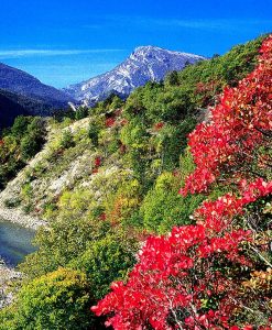
Ste-Victoire, La Montagne 4-5, 56, 58, 59, 60, 125, 126-7, 128-9
Salles, Les 43
Samson, Couloir 47, 117, 118-9
Sausses, Les 38
Saut des Français 23
Scaffarels, Les 35, 109, 110
Seillans 28
Séranon 29, 100, 101, 102, cover
Vieux 100, 101
Siagne, Gorges de la 29, 99, 100
Canal de la 99, 100
Siagnole, Sources de la 96, 97, 97
Sigale 37, 39, 112
Sillans-le-Cascade 55
Soleilhas 39
Soleils 41, 47
Pont de Soleils 41, 47
Sospel 14-5, 18, 81, 83
Tavernes 10, 56, 57
Théoule-sur-Mer 11, 74-5
Tholonet, Le 56, 60, 128-9
Thorame-Haut-Gare 31, 131
Thorenc 22, 25, 26, 29, 30, 33, 36, 37, 95
Thoronet, Abbaye du 55
Tourtour 37, 42, 115, 116
Toutes Aures, Col de 35
Trayas, Le 11
Trécolpas, Lac de 85, 86-7, 88, 89
Trescaïres, Les 44, 46, 118-9
Trigance 41, 45, 47
Turbie, La 16, 77
Turini, Col de 15, 18, 19, 21, 84
Tusset, Pont du 43, 118-9, 120, 121
Tuves, Pont des 99, 100
Utelle 22
See also Madone d’Utelle
Valberg 34
Col de Valberg 34
Valderoure 30
Valensole Plateau 49
Valescure 13
Valferrière, Col de 27, 29
Var (river) 107, 108, 109
Varages 57
Vascognes, Pont de 111, 111
Vauvenargues 58
Verdon (river) 6-7, 31, 37, 39, 41, 46-7, 117, 118-9, 120, 121
Verdon, Grand Canyon du 2, 43-49, 44, 46-7, 117, 118-9, 120, 121
Vergons 36
Clue de Vergons 36
Vésubie (river) 17, 18, 19
Gorges de la 17, 22, 23
Vidauban 50, 51
Vidron, Chalet 15, 85, 89
Villaron, Pont de 30, 31
Ville 33, 37, 40, 113
Villecroze 50
Villeneuve-d’Entraunes 34
Vinaigre, Mont 14
Vistaëro, Belvédère du 16
Zola (lake and dam) 58, 128-9, 129
Eastern Provence, 3rd edition (2016) and 4th edition 2021 in pdf form from our website. Updated 9/10/20
Updates for walks and car tours (drives) in eastern Provence and the Côte d’Azur given below supplement those provided in the guidebook. It is vital that this Update is read in conjunction with the text of the book, but note that the Update applies only to the edition stated and not to any earlier editions. (If you have an older edition of this book you can “upgrade” to the latest edition at half price.)
Information has been forwarded to us by users of the book, and Sunflower Books offers the data in good faith but cannot be held responsible for any misleading or inaccurate content in the Update. Unless indicated otherwise, what appears here has not been verified by the author or publisher, so please allow due caution when new or amended routes are suggested. Each piece of information is dated; bear in mind that some of the older observations may have since been overtaken by events or further changes. If, during your holiday, you are using the current edition of the guide and are able to provide any additional updating to add to this page, we will be pleased to hear from you. Please send information, preferably by e-mail, to info@sunflowerbooks.co.uk.
IMPORTANT: THIS REFERS TO ALL EDITIONS OF THE BOOK, INCLUDING THE 4TH NOT YET PUBLISHED IN BOOK FORM. THE DISASTROUS STORM ALEX HIT THE SOUTH OF FRANCE IN THE EARLY DAYS OF OCTOBER 2020. THE WORST DAMAGE HAS BEEN IN THE VESUBIE VALLEY (CAR TOUR 2), WITH THE VILLAGE OF ST-MARTIN VESUBIE COMPLETELY FLOODED AND CUT OFF. THE CAR TOUR WILL NOT BE POSSIBLE FOR MONTHS, NOR WILL SOME OF THE WALKS ACCESSED FROM IT. THE DEPARTEMENTS OF ALPES MARITIMES AND VAR WERE THE WORST HIT AS FAR AS WE KNOW, AND WE EXPECT THAT IT WILL BE SOME WEEKS OR MONTHS UNTIL WE KNOW EXACTLY WHAT THE PICTURE IS.
ALL THE OTHER COMMENTS BELOW HAVE BEEN INCORPORATED IN THE 4TH EDITION, CURRENTLY AVAILABLE ONLY IN PDF FORM FROM OUR WEBSITE BUT TO BE PUBLISHED IN BOOK FORM EARLY IN 2022. [SUNFLOWER]
Walk 2 Mont Chauve d’Aspremont. NB we did the Alternative Walk – Aspremont Circuit which we thought was stunning. Fabulous flowers en route in May and fabulous views… It is worth pointing out that the Fort is a continiuing military establishment – you cannot enter – as we were politely told by an official at the summit… We found the tunnel mentioned on the return to Tourette to be closed (locked) at the far end having already stumbled our way through. Ignoring the tunnel and continuing on the waymarked path towards Basse de Guingo brings you to the outside of the far end of the tunnel nevertheless… Waymarking at Basse de Guingo for the return to Aspremont is missing – Need to stress to look for the wide grassy path leading downhill to the right of the one you have just arrived by… There now appear to be three restaurants in Aspremont village centre and a small, friendly Relais – which offered welcome refreshments after the walk. (User, 5/16) • We also did the Alternative return to Aspremont. We didn’t get around to checking for updates before we left the UK, but agree with the comments made by those who took this walk in May, that the path via the tunnel is no longer a viable “slightly different” route. There was also rapid gun fire, at what we assumed to be a shooting range coming from the ruined fort area, so keep well away. Follow the path after the entrance to the tunnel and as you descend to a junction of paths, with a basin ahead, turn sharp left downhill and make your way back to Aspremont via the grassy path, which was rather brown and well worn by September. (User, 9/16)
Walk 3 Peillon and Peille. At the start of the return from Peille village you could make it clearer that you zigzag down grassy footpaths to the last hairpin, not the road itself. NB there is a red painted wooden ‘Peillon’ signpost, indicating the route to follow to the right, halfway down the zigzags which cuts off a fair number of the road hairpins. You can also follow orange painted arrows and XMB markings on the ground which indicate the paths to take… The path to follow through the woods after crossing the stream is now quite clear with apparently freshly painted thick yellow flash markings showing the way… We didn’t see the large boulder mentioned with red and yellow marks but didn’t need to as the route ahead seemed quite clear… The ‘second tall cairn’ at the ‘important junction’ no longer exists but the onward path is clearly marked with a left handed upside down L flash clearly pointing to the left. Branches have also been laid blocking the path straight ahead as a further indication to turn left… Again ‘2 minutes later at a Y-fork’ the right hand path is clearly marked with a yellow L flash and branches blocking the path in front… We didn’t notice the building mentioned at 2h 55 mins but arrived at ‘col and marker stone 128’ without problem… NB we thought both Peillon and Peille were more picturesque villages than Eze – which is very commercialised and touristy. (User, 5/16)
Walk 5: The walk starts at the Colle de Belle Barbe and heads towards Lac de L’Ecureuil. I quote from the guide as one approaches the Lac: “Soon the sound of rushing water heralds you approach to the tiny Lac de L’Ecureuil.” It may have done once but the Lac de L’Ecureuil, despite still being shown on Map 3544ET, is now completely dry and clearly has been for several years looking at the tree growth. I don’t think it has dried out. What I think has happened is that the bank at the southern end of the Lac must has given way at some stage releasing all the water. There is no rushing water and definitely no lake and it is unlikely there ever will be again. (User, 6/18)
Walk 8 La Turbie and Eze (alternative La Turbie Circuit). The two tunnels and the path between them on the Corniche track just after the Maison de La Nature are both currently closed and this whole section blocked off due to maintenance work repairing the roof of the tunnels. The route to follow is sharp left at the first tunnel to the Table d’Orientation to follow the ‘sentier botanique’ in reverse. A good 20 minutes diversion but very pretty in its own right. (User, 5/16)
Walk 12: Unless you wish to buy cheese form the Vacherie we suggest that having walked to the picnic area from the Col de Turini, go left downhill to meet a flagpost to Circuit de L’Arphia as Flagpost 235 is beyond the Vacherie. In the clearing at spot height 1648 there has been recent logging activity. The Flagpost 235A is fixed to a tree and has been damaged. Upon your return to the Col de Turini enjoy refreshments at the café within the Hotel des Trois Vallees and if you are an historic motorsport fan, you will be immersed in memorabilia and photographs of rallies past and present. An unexpected bonus for me! (User, 9/16) [Authors’ comment: We love the Trois Vallées, as is evident from our book ‘Walk & Eat around Nice’.]
Walk 13: The GR52 from Flagpost 423 to the Vacherie du Boreon is poorly waymarked and you need to take care to follow a number of cairns to stay on the GR52. (User, 9/16)
Walk 14: Flagpost 357 is not to the left of the CAF, it is adjacent to the chapel & hotel where there is also a WC sign. Walk up the steps to the left of the CAF to the large map boards to start this walk. (User, 9/16)
Walk 15: Good news! Flagpost 429 has been replaced. (User, 9/16)
Walk 16: At the 1h15min-point the stepping stones have been supplemented by a timber bridge. (User, 9/16)
Walk 24: At Flagpost 56 you need to look carefully for the narrow footpath slightly to your left. Do not go down the steep wider path that is immediately to the left of the house. Flagpost 56A is not labelled as such and in walking distance it is more than 60m downhill from Flagpost 56; it is probably 200 to 300m. At 1h25min it is not clear that you have reached the Fuont Nouvelle. The footpath we walked had been trodden to the right of the concrete capped well. The wooden siting post mentioned had broken off and was not visible until we reached the ridge and Flagpost 57A. (User, 9/16)
GPS files for use with Landscapes of Eastern Provence:
Download GPS files for Landscapes Eastern Provence
iPhone users need a free or paid app to open the zip file and see the files stored inside it. There are a variety of apps that can open zip files on the iPhone, but Zip Viewer is one of the easiest to use – and it is free.


